Here are the latest posts, going back to Tuesday, April 21:
Tuesday, April 21
Yesterday evening, Peter and I walked around the nearly deserted streets of the old part of St. Augustine with our N95 masks. Homeless people made up a good proportion of the people we saw. Shops, bars and restaurants were locked up, but menus were still illuminated, and Peter could not keep himself from stopping and salivating over the enticing selections. The only place that was open was a gourmet grilled cheese sandwich shop. Although the food wasn’t fancy, Peter was able to get meat; he ordered a sandwich with brie, bacon, balsamic vinegar and raspberry sauce. The only other customers were two homeless people with a dollar. The woman was asking for milk for an upset stomach. The caring woman who was working there gave it to her for free, and then the people used the single to purchase a can of Coke. I wondered how that might help with gastric issues.
Back at the marina, we settled in for the night, listening to the quiet clicking of shrimp against the hull as we fell asleep. It was just cool enough to need a quilt.
This morning, we cast off the dock in time for the 9:00 opening of the Bridge of Lions. Out on the Atlantic, the seas were calm and the wind was nearly non-existent, so we motored north. I really wished for a book to read. Peter and I played cards and I napped some of the time. In the late afternoon, the wind picked up enough that we could turn off the engine and enjoy a couple of hours of pleasant sailing, averaging 9 knots. We came through St. Mary’s Inlet, the coastal border between Florida and Georgia, and headed north to an anchorage along the inside of Cumberland Island National Seashore. Unfortunately, the park is closed, so we cannot explore this pristine environment full of natural delights and history and enjoy ranger-led tours.
 |
| Cumberland Island dock |
There are ten other boats in this peaceful anchorage. To the east is the U.S. Naval Submarine Base Kings Bay, the Atlantic Fleet’s 20,000 acre home port for ballistic missile nuclear submarines armed with Trident missile weapons. I am not sure if I should feel safe or in danger being near a strategic target!
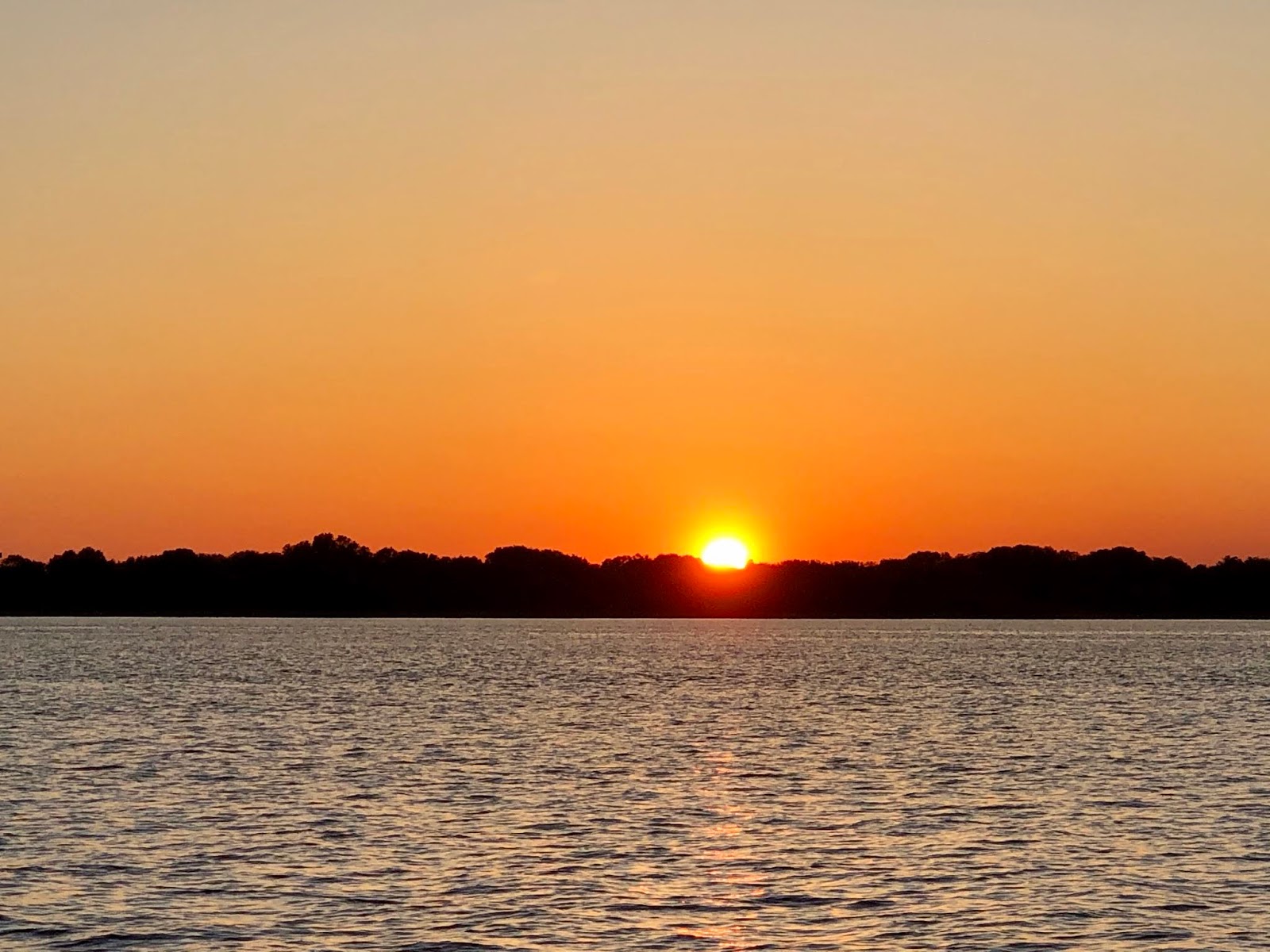
 |
| Sunset by Cumberland Island |
I am not at all sure that I am happy to be back in the U.S., where I have uninterrupted cell phone coverage and therefore limitless access to the news. The COVID-19 pandemic as a health and welfare emergency is very distressing, but what is really depressing and disturbing is the response within the United States to this new reality. I am acutely reminded of why I wanted to acquire another boat and escape the madness. I make a point of not relying on news outlets for information; I prefer to go to the sources that are not associated with politics such as the websites for WHO, the CDC, the NIH and even comparable agencies of other countries. If I only accessed information from U.S. media sites, whether it be NPR, CNN or Fox News, I might think that the federal government responses to the crisis, protests against stay-at-home orders (including people armed with semi-automatic rifles!), the focus on getting businesses to open again despite warnings of a resurgence of cases, and lawsuits and other attempts to assign blame were the norm throughout the world. But the BBC, the Guardian, the CBC, and Al Jazeera, among others, reveal that the U.S. response is not in line with that of most other countries in the world. The rest of the world looks on with incredulity and horror at the way the U.S. was slow to respond, the denial of data and science, the lack of preparation, the placement of economic stability or even gain over public health and welfare, and the tendency of a large proportion of the American public to feel personally victimized and angry at infringements on their personal liberty regardless of the needs of society as a whole. The pandemic is worrying, but the response in the U.S. (with the exception of certain States and communities) is disheartening and, I believe, symptomatic of the disunity, fear, hatred and moral failings of our society. I wish I knew what I could do to make things better, but I feel overwhelmed and impotent.
Wednesday, April 22
Today we motored up the ICW for a few meandering miles, going from the southern end of Cumberland Island to the northern end. The coffee brown water is teeming with life that we do not see, but occasionally dolphins delight us, rays fly out of the dark but glistening water and smack back down out of sight. Peter caught a glimpse of a manatee breaking the surface for a breath of air.
While, as sailors, we tend to malign the ICW, we actually found this stretch peaceful and pleasant. The breaking waves of the Atlantic are only a couple of miles away, but their proximity is not felt here. The currents flow and the tides go up and down a couple of feet, constantly changing the fluid border between the open water and the marshes which stretch seemingly endlessly in all directions. We found a tranquil place to anchor on a bend of the Brickhill River.
 |
| Late afternoon, Brickhill River |
 |
| Kayaking on the river |
 |
| Sunset and flat water |
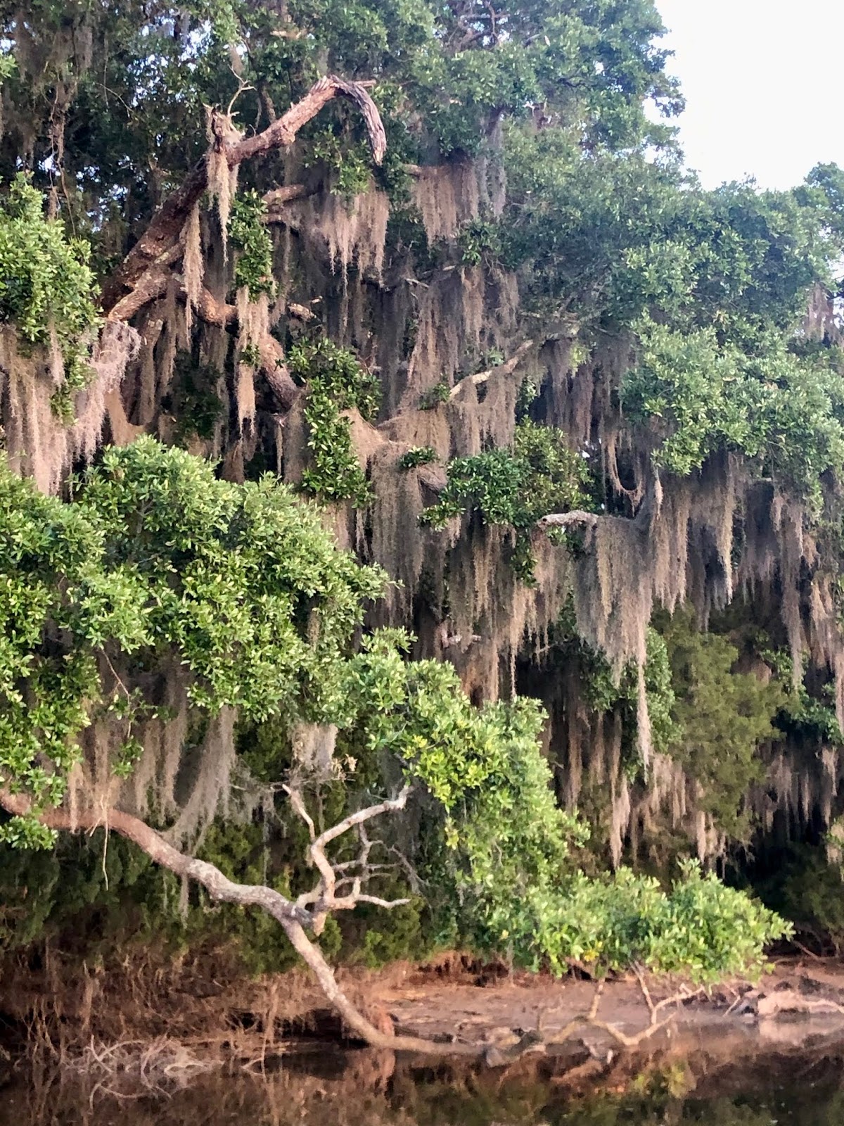
 |
| Spanish moss in the trees |
One other boat was anchored around the bend. Ordinarily, cruisers fire up their dinghy engines or paddle their kayaks or SUP’s in order to meet those around them. This is no longer happening. Yesterday, with a line of boats in sight of each other, we were all isolated.
Like everyone else, Peter and I have a lot of time on our hands. We played Scrabble in the afternoon and then, about an hour before sunset, launched the kayak and paddled up a wide creek. Spanish moss hangs in great weighty masses from the branches of the trees on the shore of Cumberland Island. Although most of them remain out of sight, birds are abundant. Jet black red-winged blackbirds look like dark, single-colored creatures until they take flight from their perches on the top of the marshes and flash their red epaulets.
The cold front, with its strong winds, could be seen moving in from the west, making the sunset streaky with dark and light patches of blue, gray, coral and yellow as the sun was obscured by the thick clouds.
While we are eager to get home to California, the weather does not allow us to move swiftly up the eastern seaboard. Rather than be frustrated, we are trying to enjoy the slow pace of cruising along the coast and exploring the wetlands behind the barrier islands. We regret that there are so many places on land that we cannot visit, but, we appreciate the mobility we have on our second home.
We try not to be overcome with worry and remain positive and upbeat during this pandemic. I now have a slight cold. Normally, this would be nothing, but we have to consider that somehow I may have contracted COVID-19, perhaps from the unmasked woman at the grilled cheese sandwich restaurant in St. Augustine. Katya seems to be doing well at home, getting out a couple times a day for walks and staying in touch with wonderful neighbors. Matthew, I’m afraid, is terribly isolated in his dorm room in London, and he also felt ill for a few days. It is not good, but we must make the best of this situation and not fail to be cautious.
Friday, April 24
 |
| Stormy weather on April 23 |
Because my laptop was in the oven yesterday evening, I did not make a post to the blog. Thursday, April 23, was both an exciting day and a boring day. It held excitement because the weather was temperamental, and we received several alerts on our phones and on the VHF radio regarding tornados and severe thunderstorms. Although the tornados were slightly northwest of us, they are a bit unpredictable in their paths, so we brought all the seat cushions, life jackets and other things that normally stay in the pilot house down below. The thunderstorms posed a greater risk because of the lightning. We put out an extra sacrificial zinc, but still the top of our mast, at 65 feet above water level, was the highest thing around. During the first storm, we put our laptops in the oven, which functions as a Faraday cage, and started the engine, a trick we learned from another cruiser in Panamá. If lightning would fry all the electronics, then we would be unable to start our diesel engine because the starter is electric. The thunderstorms were awesome, and fortunately we avoided a lightning strike.
Other than watching and preparing for the weather, however, the day was fairly boring. We were down below most of the time. Peter and I played what has become a daily game of Scrabble on the days we are anchored. In the evening, we played cribbage. We listened to the news and were able to do some online reading of various media outlets while we had a bar or two on our cell phones.
Each night, once it gets totally dark, we become surrounded by underwater noises. Various animals must emerge from the murky bottom for a feeding frenzy which lasts a couple of hours. A continuous tapping, as if tireless and submerged woodpeckers are busy, is accompanied by a churning sound, like the noise made by a washing machine when it is agitating the clothes. There are quiet clicking sounds and a dull, low rumbling. Last night, these noises were somewhat muffled by the rain like kettledrums being played on the deck above our bed. The night was chilly, and in addition to the light quilt which we got out a couple of days ago we threw a fleece blanket on top of the bed.
Today, my cell phone could not pick up a signal although we haven’t moved, so I was unable to communicate with my family or friends. The day started out gloomy. There was Scrabble and I studied Spanish for a while and even did a bit of strength training in addition to making meals. By mid-afternoon, the dark skies had become a canopy of light gray clouds crowding each other for space. Around 4:30, at low tide, we set out in the kayak. The mouths of the creeks, which had been wide open two days ago, were narrow openings as the water level was about two meters below the high tide. The marshes stretching endlessly to the horizon did not seem like great open expanses at low tide. As we entered the creeks, we lost this sense of wide open space and found our perspective limited by the exposed mud and oyster beds, the roots of the reeds and the three foot plants enveloping us on either side. The serpentine paths of the water further confined our view. We could see the tops of trees in the distance to the east but not the top of the marshes.
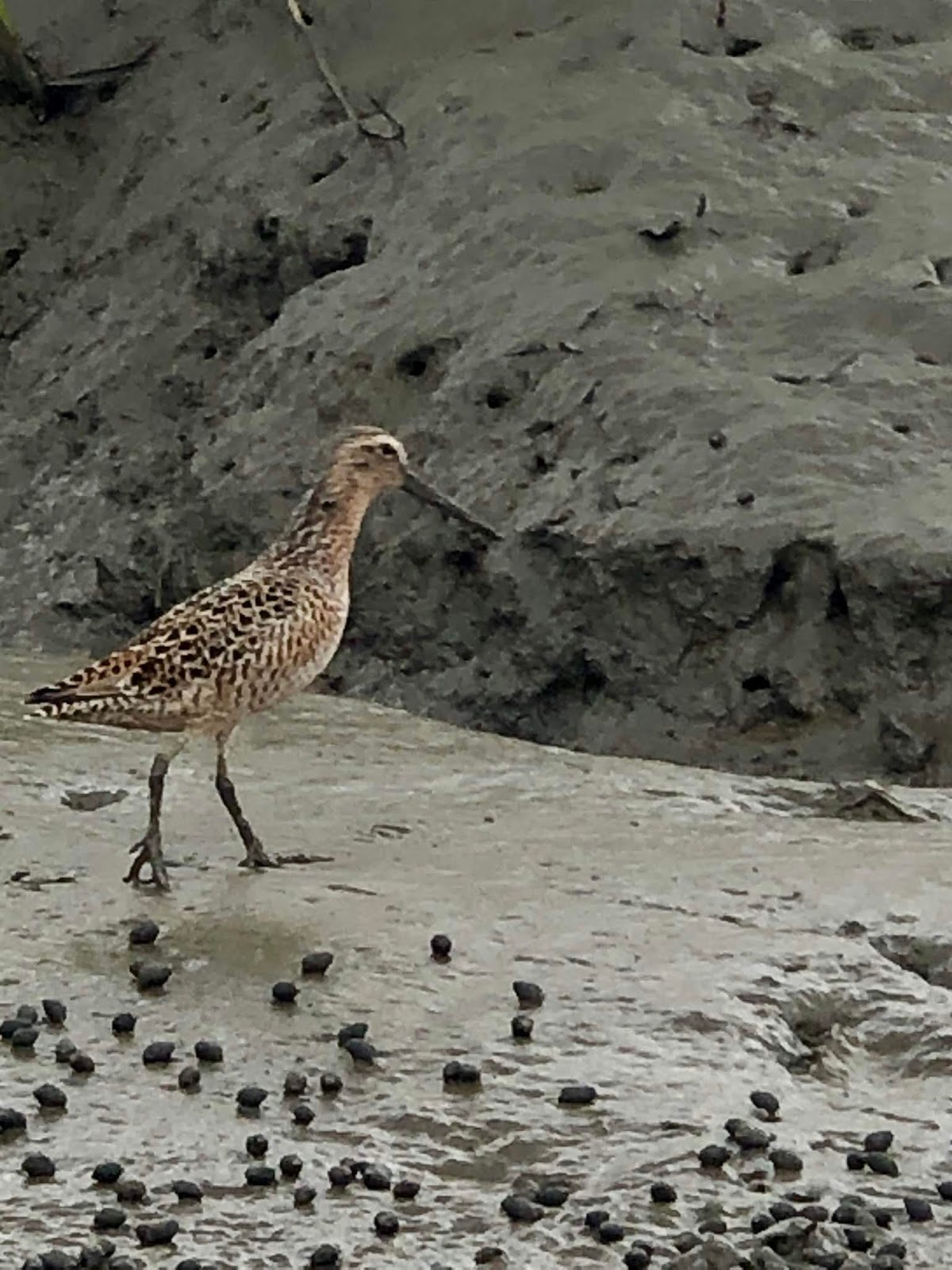
Within these wandering waterways we enjoyed the abundant birdlife. On the mud flats were many species of sandpipers, including the red knot, and we also saw herons, snowy egrets, Bonaparte’s gulls, red-winged blackbirds and wood storks. As we slowly paddled along, a golden eagle passed overhead, its wingtips curled up to aid its flight. It landed on the muddy shore not far from us.
 |
| Shiny dolphin approaching us from the side before diving under our kayak |
In addition to the birds, we encountered dolphins in the backwaters several times during our three-hour exploration of the wetlands. Once, they rushed toward the shore and almost seemed to explode onto the mud as they corralled fish. Another time, they approached us closely, and one swam toward us from the beam and then smoothly dove under us and popped up on the other side. We finally paddled back to Mantra as the no-see-ums became obnoxious.
 |
| Low tide, Brickhill River |
 |
| Red knot |
 |
| Oysters at low tide on the shore of the marsh |
 |
| Red knots |
After a day of practically no sunshine, the glowing orange orb descended below the clouds just above the horizon and made a spectacular exit from the sky, turning the surface of the green-brown water a deep indigo.
Saturday, April 25
As bottlenose dolphins swam around us this morning, we pulled up anchor at 9 a.m. and headed out to sea with only 5 knots of wind from the east, knowing we would have to motor. As we used the charts to navigate out through St. Andrew Sound; or, I should say, we tried to use the Garmin and Coastal Explorer charts, but both proved to be totally inaccurate. We found just one or two meters under the keel when there should have been a dozen and 8-9 meters in areas that should have been impassable. We almost ran aground on shoals a couple of times, and navigating by feel through the sound seemed to take forever as we took our best guesses on directions. Once we were out in open water, we motored over a consistent 10 meters of depth for miles. The offshore route was about 25 miles long while the actual distance we traveled as the crow flies was about 10 to reach the northern end of Jekyll Island. What I did not realize was that we could have traveled on the Intracoastal Waterway in a couple of hours, and there was only one fixed 65 foot high bridge to pass under. Peter thought he had told me this, but perhaps, he said, he only thought about it! So, a trip that could have been a couple of hours took exactly 7!
 |
| Dragonfly on the running rigging while we were out at sea |
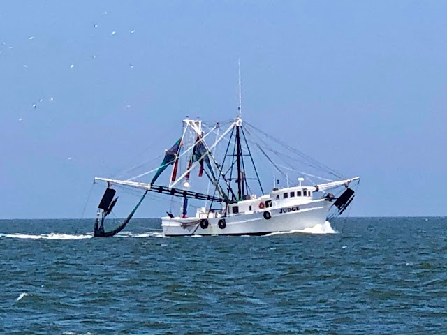 |
| Shrimp boats were everywhere |
Since we were out to sea more than 3 nautical miles from shore, we were able to pump out the holding tank for sewage. In tropical waters, the effluvia is a distinctly different color than the surrounding turquoise waters. On the Atlantic coast of the eastern seaboard, it is difficult to discern the difference between that which is being pumped out and the water into which it is being discharged.
The unanticipated advantage of traveling offshore was that we got a close look at something amazing. As we approached St. Simon’s Sound, from about 3 miles out at sea we could see an enormous construction project in the harbor; it looked like a single structure was being built that was bigger than a football field with a large, smooth roof. There were giant cranes and a lot of structures around it. We could not figure out what it was until we got closer to shore, picked up a cell signal and used Google. Then we realized that the piers, cranes and structures were surrounding the 200 meter long hulk of the Golden Ray, a shiny blue cargo vessel that had listed and then capsized in about 15 meters of water in September 2019 after leaving the port of Brunswick less than an hour before. All the barges, piers and other things surrounding the hull are there to mitigate pollution and prepare for cutting the ship into eight pieces in order to remove it from the channel. It was an astounding sight.
 |
| The capsized Golden Ray |
 |
| The capsized Golden Ray |
By the time we anchored at 2:00 p.m. off the western side of the northern end of Jekyll Island, where we could see people walking and riding bikes on the beaches, the wind had picked up to 20 knots from the south, making the water too chopping for pleasant kayaking. Luckily, from the deck we could see dolphins, which are amazingly abundant, and we spotted a couple of loggerhead turtles. Unlike in the Caribbean and the Gulf of Mexico, they can only be seen when they surface because the milky coffee water is almost opaque.
Sunday, April 26
With the winds expected to get high in the afternoon, we chose the ICW today. We had to pull up anchor at 7 a.m. to go under fixed bridge across Lanier Island at low tide; we cleared by about a foot. (We will never forget the time we hit a bridge in our previous boat on the ICW, and we always approach the structures with some trepidation.) After we were under the bridge, I made Peter a cup of tea and then returned to the warmth of our bed. The last couple of days we have worn jeans. It’s the first time I have not been dressed in shorts and a t-shirt, a sundress or a swimsuit since the end of January!
I meant to catch another hour of sleep, but the gentle movement of the boat and the purring of the engine lulled me into a deeper slumber, and it was approaching noon when I emerged from under the covers! Peter had steadfastly kept us on course in the meandering waterway, amusing himself from time to time killing the large flies that alight on the underside of the canvas bimini. They are tough and not easily destroyed, but we are perfecting our technique!
We stopped for lunch at the mouth of Shellbluff Creek and listened to the weather forecast. The wind is supposed to be 15-20 knots from the west with gusts up to 25 tonight; in fact, it was already gusting to 20 as we listened. We had planned to anchor on the north side of Blackbeard’s Island but decided to motor a few miles further north to Wahoo River for better protection from the wind.
 |
| A family shrimp boat heading out |
 |
| Typical home on shore along this section of the ICW |
Another, smaller sailboat passed us heading north on the ICW just as we were pulling up anchor at mile marker 161. We realized as we got out into the channel that he had put up his genoa but didn’t seem to be moving. Unfortunately, he was not. He had strayed too far to the west side of the channel, although he was still within the markers, and had run aground. Hailing from Cambridge, Maryland, he was sailing solo and was trying to use his genoa to power off the shoal, to no avail. We offered to help, but really there was little we could do in the narrow channel. As we passed him slowly, several small local powerboats indifferently sped by leaving enormous wakes as their oversized “Trump-Make America Great Again” flags flew out stiffly behind them. I guess this is not surprising since they are people who adore a man who has shown little compassion or empathy for the thousands who have perished in the pandemic as he touts dubious accomplishments and raves about getting the economy back on track or even “better than ever.”
Anchored in the Wahoo River, we had an afternoon snack and played Scrabble for a while but paused the game to do some exploring in the kayak before sunset. We went to Wahoo Island, which has a mysterious, lit-at-night lamppost and no other development. The beach is eroding, so perhaps plans to build were scrapped. A think layer of sand covered the clay soil, which came in three colors, coal black, clay red and cement gray. The erosion showed the levels each type. Part of the small beach was covered in thick shells of ancient mollusks, and the four foot eroded bluff by the beach showed them in abundance in the soil. This only was in a little section, about 30 feet long, and we surmised that what was being eroded and exposed was a Native American midden.
 |
| Exposed Native American midden, Wahoo Island |
 |
| Chunks of black clay on the beach |
 |
| View from the beach with Mantra in the distance |
 |
| Clouds from the kayak at sunset |
 |
| Sunset behind Wahoo Island |
Monday, April 27
We woke up to a cold morning, with temperature below 50 degrees Fahrenheit, but a bright blue sky. Bundled up in sweaters and jackets and jeans, we got under way as dolphins frolicked. We motored most of the day up the ICW, past endless stretches of marshes and open water and tributaries. Occasionally there are hammocks of hardwoods slightly higher than the wetlands. As we traveled and looked all around us, even though we knew and our charts showed that we were moving through flowing water that was behind us and ahead of us, it appeared that we were in a lake surrounded by yellow-green reeds in all directions.
As we got closer to Savannah, we started to see more development, particularly enormous houses with private docks. At 5 p.m. we pulled into the Isle of Hope Marina, and since then we have been very busy. I went to the nearby Super Walmart for groceries and was dismayed to see very few people wearing masks or even following the one-way aisle pattern. Even employees were cavalier about protection; some of them were wearing masks just over their mouths but not their noses. When I asked the check-out clerk about this, she said she knew it wasn’t effective but she didn’t want to be wearing one at all. Employees checking receipts outside the exit were wearing no masks and certainly were not six feet away from customers.
When I returned to the marina, I unpack and put away all the groceries, did a couple of loads of laundry, made dinner and downloaded photos. It is now after midnight, and I am exhausted. And we have to leave here by 8 a.m. to use the tide to our advantage for passage under the next fixed bridge.


No comments:
Post a Comment