I'm back! We have finally reached a place where we have a reliable and strong Internet connection, and I have been able to catch up on downloading, editing and labelling photos and now it is time to bring the blog up to date.
On Sunday, Sept. 4, after a nice stay in Northeast Harbor, we left the mooring field and headed to what is called the Bold Coast, first destination Mistake Island. We had good wind for sailing on a broad reach and made good time, although we did have to heave to and disentangle ourselves from toggle lines connecting two lobster buoys twice! At least it was good practice in stopping the boat and drifting backward--useful for man overboard recovery.
We arrived in Mistake Harbor (the name supposed to be a corruption of a Native American name), rounding the southeast end of Mistake Island, passing the Moose Peak Light, heading NW with Knight Island on our starboard side and turned in to the Eastern Bay, anchoring with Mistake Island to the east and Water Island to the west. Only one other boat was in the anchorage. It was very peaceful and the scenery was lovely. We thought of kayaking to shore before sunset but felt like relaxing. This may have been a mistake because rain set in that evening and we stayed on board all day on Monday as the rain continued, and we never explored the land.
 |
| Passing by Knight Island |
 |
| Buoys in the passage |
 |
| Moose Peak Lighthouse |
 |
| Seal in the harbor |
On Tuesday, Sept. 6, the winds were light, so we motored to our next stop, Roque Island, the site of the greatest beach in Maine. The white sand beach stretches for a mile along the crescent-shaped shore. After lunch, we kayaked to the shore and took our time strolling in the fine-grained sand and observing the features of the island.
 |
| Peter walking along the beach |
 |
| Patterns made by the ebbing tide |
 |
| Roque Island beach |
 |
| Peter and Sherri enjoying the beach |
The native Passamaquoddy Indians used the islands of the archipelago for seasonal camps. It was intermittenly settled by whites in the late 1700s, and in the early 1800s, Joseph Peabody of Salem, Massachusetts acquired the deed to the island. His descendants inherited it in 1844, particularly his daughter Catherine, who was the wife of John Lowell Gardner of Boston. Though previous to Peabody's death the land was used for shipbuilding and farming, these activities ceased and the island became a summer retreat for the family. One family member was the wife of James Gardner, Isabella Stewart Gardner, whose museum I visited with Louise in early July.
The family, organized as a corporation since 1940, still owns the 2500-acre, nine-island cluster. Members of the board of the corporation must be 18 years of age and direct descendents of George Ausustus Gardner. There are over 60 board members now, and family vacations must be scheduled far in advance for the three houses on the main island.
 |
| Peter and Sherri bundled up for sailing |
 |
| Little River Island Lighthouse from Mantra |
 |
| Buoy showing the strength of the current |
We enjoyed a very peaceful evening in Roque Island Harbor and then pulled up anchor before 9 a.m. to use the current to reach Cutler, Maine, the last stop before Canada, on Wednesday, Sept. 7. At noon, we anchored south of most of the moorings and were still on deck when a man and his son motored up in their skiff. Kurt, the father, is also an OCC member and had seen our burgee; he and his wife recently completed a circumnavigation. The two came aboard to chat, keeping us informed about every lobster boat that came into the harbor. Before they left, they invited us to their house on the hill overlooking the harbor for lobster dinner (pasta for me). This was very kind of them, and we accepted, although we hadn't planned to launch the dinghy. Not a problem. Swen, the son, would pick us up at 6.
After lunch, we launched the kayak and paddled to Little River Island as recommended by Kurt and Swen. The light station has been owned owned by the American Lighthouse Foundation since 2002 and cared for by the Friends of Little River Lighthouse, although the Coast Guard still operates it as a navigational aid. There is a boardwalk through the woods to the ocean side of the island and the buildings. The 41-foot lighthouse was built in 1876 and was a three-man station until 1973, when it became a one-man station. The actual light was moved to a skeleton tower in 1980, but, through the efforts of the American Lighthouse Foundation, it was restored to the top of the lighthouse in 2001.
 |
| Little River Island |
 |
| Staircase to the top of the lighthouse |
 |
| View from Little River Island |
 |
| Little River Island Lighthouse |
We met the man who is the caretaker, who was cooking in his kitchen. Terry Rowden first came to the lighthouse in 1968 and served as the lightkeeper there until 1970 as a member of the Coast Guard. Now, he and his wife are in charge of maintenance and the operation of the facility as a guest house. The inside of the house still retains its mid-20th century appearance, with a formica-topped kitchen table and older appliances, rag rugs and mid-century furniture.
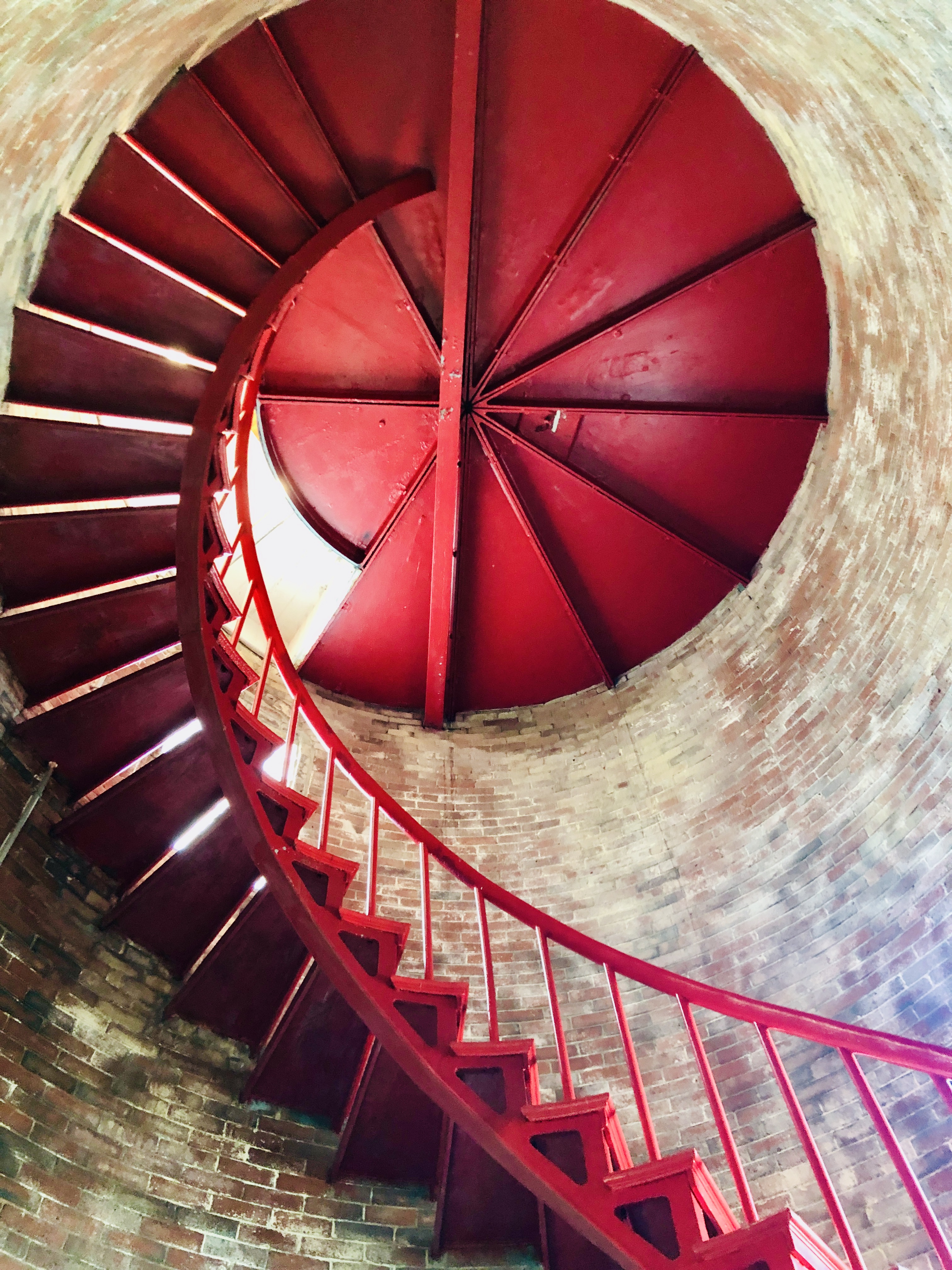
After chatting with Terry, we took the spiral staircase up the inside of the lighthouse. The views from the top are amazing, and we observed that everything is meticulously maintained. We were able to crawl through the hatch to the outside for unobstructed panoramas. We walked above the sea among wildflowers and evergreen trees before returning to the dock, which was partially submerged in the water with the high tide.
 |
| Peter at the partially submerged dock |
 |
| View of Cutler from the kayak |
At 6 p.m., Swen picked us up and, from the dock, we climbed the 80 stairs to the sloping lawn and found Kurt busy in the kitchen. Their home is lovely, and we had a particularly relaxing and enjoyable time with them, enjoying the good food and wine and beer and interesting conversation on a variety of topics. Kurt's wife is already in Newport, Rhode Island, and Swen and Kurt were sailing off the next morning to Narragansett Bay. Like us, they are taking their boat to New England Boatworks in Portsmouth, RI, for work, so it is possible we may meet again.
To take advantage of the current, we set off a dawn on Thursday, Sept. 8, for New Brunswick. We were expecting waves from recent hurricane activity around Bermuda, but the sea was glass, although we could feel gentle swells. There was absolutely no wind, so we motored. We crossed into the Atlantic Time Zone, so it was 11 a.m. at our destination, Head Harbour Public Dock on Campbobello Island. From there, we contacted Canadian authorities by phone and cleared into the country.
 |
| Head Harbour Light |
At 2 p.m., we cast off the dock lines as the tide continued to ebb, and went to Doctors Cove on Deer Island where we anchored for an hour and a half to wait for a favorable current to take us to Saint Andrews. Around 4:30, we raised anchor and rounded the southern tip of Deer Island and passed by the Old Sow Whirlpool, the oldest one in the western hemisphere. At this place, there is a 20 foot tidal range and the waters of the Bay of Fundy and Passamaquoddy Bay are exchanged. This, along with the particular bathymetry of the seafloor in this location, causes a vortex that can be 250 feet in diameter. Of course, this is not what we saw because we chose our time for minimal turbulence. We could feel the currents shoving the boat and see a vortex a few feet in diameter, but safe passage necessitated not heading up the Western Passage of Deer Island at Old Sow's peak.
 |
| Old Sow |
In Saint Andrews Harbour, we picked up a large mooring ball at 5 p.m. As Peter was securing the lines, a man came by in his dinghy to tell us that we were welcome to use the ball (In fact, he was coming to us to recommend it before we snagged the pennant.); a friend of his owned it and was not using it this season.
The next morning (Friday, Sept. 9), we set off in the dinghy for town. We were overdressed for the weather on shore that day and for at least some of the time felt sweaty in our jeans and t-shirts; our fleeces were tied around our waists. At the dock, we took showers and then left our toiletries and towels on the dinghy to walk around. We strolled up King Street (named after King George III), passing old buildings and churches. In 1783, at the end of the Revolutionary War, the town was settled by American Loyalists wanting to remain part of the British Empire. It was laid out in a typical grid. Except for Water Street by the shore of the harbor, the streets are named for governors of the colony parallel to Water Street and, perpendicular to Water Street, for the children of King George III. (There are 13 cross streets.)
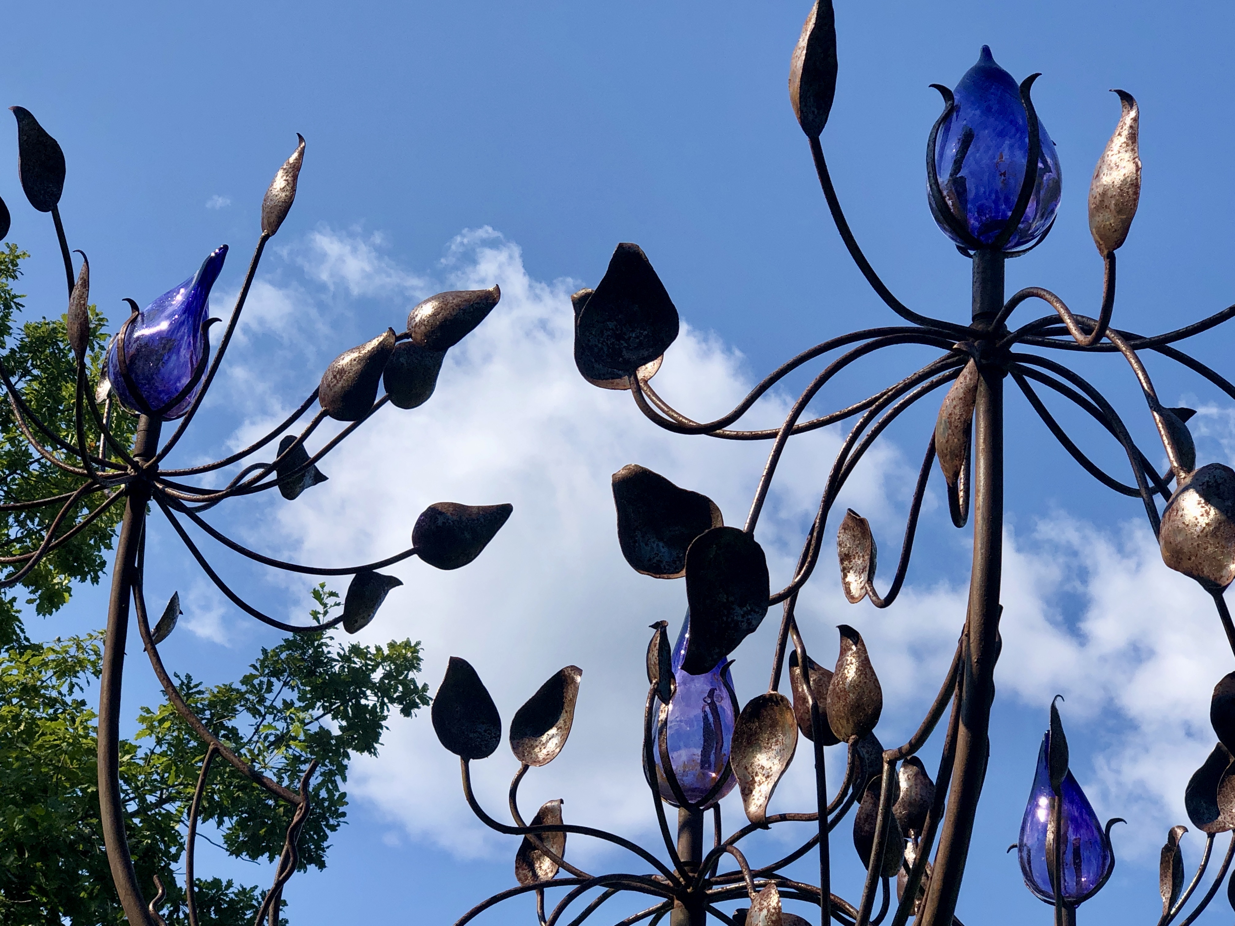
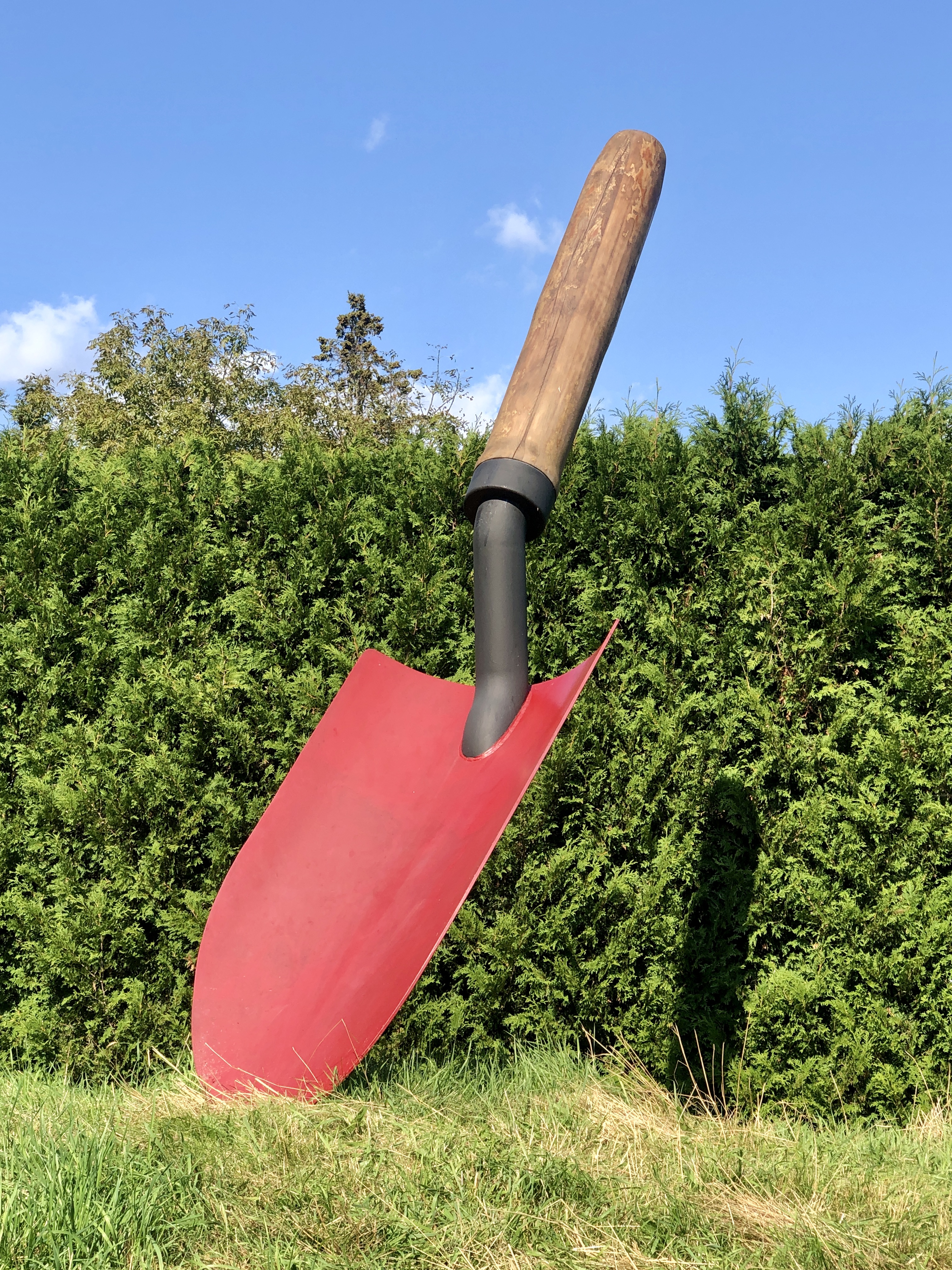
We spent three and a half hours at Kingsbrae Horticultural Garden, 27 acres of beauty. It is divided into many sections. My favorite was the large perennial garden; Peter's was the Secret Garden. We both enjoyed the Sculpture Garden, with dozens of pieces of art situated in lovely planted area. We had lunch on the terrace of the cafe with views across a lawn to the hills on the far horizon. The food was superb and filling, and we enjoyed it the shade of a large oak tree.
 |
| Perennial garden |
 |
| Orchard |
 |
| Edible Garden |
 |
| Hydrangea and black-eyed susans |
 |
| Dragon sculpture |
 |
| Peter walking in the garden |
 |
| View from the cafe's terrace |
 |
| Cafe and gallery |
 |
| Leopard sculpture |
 |
| Top of a sculpture tree |
 |
| Sculpture Garden |
 |
| Sculpture Garden |
 |
| Sculpture Garden, our favorite piece |
 |
| Secret Garden |
After spending hours in the garden, including a short stroll through the undeveloped Acadian forest, we walked southeast down the hill to the Pagan Point Nature Preserve. The preserve is the last undeveloped shoreside wetlands in Saint Andrews. The pebbly beach exposed at low tide is abutted by rich marshland with ponds and dense native plants, many of them still flowering late in the season. Its wildness was a contrast to the human designed, carefully planned and maintained Kingsbrae Garden; both abounded in treats for the eye, large and small.
 |
| Pagan Point Nature Preserve (with heron on right side of pond) |
 |
| Fawn and doe |
 |
| Deer |
Our next stop was the Algonquin Resort situated on the hill overlooking the harbor. The elegant, expansive hotel opened in 1889, in Canada's first seaside resort town. In 1914, the original building was destroyed by fire; the current edifice opened in 1915, designed in semi-Tudor style with a bright red tile roof. We had drinks (afternoon tea for Peter and a hard cider for me) accompanied by a small but tasty creme brûlée with berries.
 |
| Algonquin Hotel |
Down the hill, we stopped to visit the Saint Andrews Blockhouse, one of three defensive structures constructed during the War of 1812 to defend the harbor. Its existence was apparently was enough to keep the privateers away from the port; it never saw any action.
 |
| Saint Andrews Blockhouse |
Unlike a lot of places we stop, Saint Andrews has a supermarket within two blocks of the dinghy dock. Peter took a right at the wharf to get our grocery bags from the dinghy and I proceeded to the store to pick out items. After our grocery run, we returned to Mantra and put our feet up; they were tired from so much walking.
We observed the dramatic sunset from the wharf and then watched the full moon rise in the east shortly after that from the deck of Mantra. The spring tide was 24 feet, laying bare extensive mud flats in front of the town.
 |
| Near low water at spring tide |
 |
| Sun sinking in the west |
 |
| Full moon rising in the east |
The next day (Saturday, Sept. 10), we stayed on board. Peter finished installing the new Tiny Pilot system and in the afternoon we dropped the mooring ball and squeezed through the narrow opening into the Western Channel to drive in circles and calibrate the system.
Around 7 p.m., we began to think about dinner and decided to go to shore for a meal out. We didn't hurry and we arrived after 8 p.m. Our first choice of restaurants had stopped serving (on a Saturday evening!) at 8 p.m. and the waitress informed us that was usual for all the restaurants. Across the street, the Red Herring was serving until 8:45, so that's where we ended up. The service was excellent and the food was ok but nothing to right home about. Nevertheless, we enjoyed the evening.
It was another early start the next morning (Sunday, Sept. 11). We were off the mooring ball before 7:30 and motoring (no wind again!) toward St. John. Even though we timed our departure according to the currents, we still found ourselves being pushed around through L'Etete Passage between the mainland and Deer Island. The water was turbulent and behaving like whitewater on the rivers. We anchored around 1 p.m. behind Gooseberry Island in a bay just west of the Musquash Estuary.
 |
| Whitewater in the passage |
Peter had work to do on the boat, so it was approaching sunset we we took the kayak to shore. The mosquitoes were swarming everywhere, but with repellent we were relatively safe from bites if not the annoyance. Part of the shore is sand and part is covered in polished, round rocks approaching the size of bowling balls. On the eastern side of the bay, there are ledges of various kinds of rock, some with quartz seams. They created perfect places for rainwater to be retained as nurseries for the pests.
 |
| Mantra from the shore |
 |
| Sand and rocks |
 |
| Tumbled stones |
 |
| Mosquitoes clinging to Peter's shirt and flying around his hat |
We stayed until after the sunset and then made a hasty retreat. Paddling as fast and hard as I ever had, we were still unable to shake the mosquitoes and I had to stop occasionally to rake them out of my hair. We resorted to chemical warfare with bug spray in the cockpit and sealed ourselves down below as quickly as we could.
Pulling up anchor around 9 a.m. on Monday (Sept. 12), with death wishes for the mosquitoes, we motored once again to a new destination, the Royal Kennebeccasis Yacht Club situated where the Kennebecasis River flows into the Saint John, eastern Canada's largest river. We had to time our passage through the famous Reversing Falls for slack tide, so, just like the giant Old Sow whirlpool, we were unable to observe the series of rapids that flow inland twice a day and toward the Bay of Fundy twice a day with a difference in tidal level of about 28 feet. Navigation for anything other than whitewater kayaks and canoes is inadvisable when the natural wonder manifests itself.
We arrived at the yacht club just after noon and were greeted warmly by three members on the dock who helped us tie up. We have now been here two days and have met many of the friendly and knowledgeable members, all of whom are effusively enthusiastic about their prestigious club, which has a royal warrant granted by Queen Victoria in 1898, as well as the area of the Saint John River. This evening, Peter crewed in the Wednesday evening sailboat race, which was a lot of fun for him.
 |
| Peter (in yellow shirt) on Mustang heading off to race |
Tomorrow we continue up the Saint John River, probably taking advantage of mooring balls offered to us for our use by members of the club.


No comments:
Post a Comment