After spending two pleasant nights on peaceful Mill Creek off Ingram Bay near the mouth of the Great Wicomico River, we pulled up anchor on Thursday, June 24, around 10 a.m. and motored downstream to the Chesapeake, passing frolicking dolphins along the way. For over four hours, we had 14 knot winds from the ESE, and we were able to sail close-hauled, tacking once, average about 6.5 knots--so it was a good day of sailing. Passing the wide mouth of the Potomac River, we turned upstream near Point Lookout on its northern shore and proceeded up to the first major northern tributary from the mouth, St. Mary's River (which also had dolphins!), anchoring in wide and peaceful Horseshoe Bend at 5 p.m. After settling in, we launched the kayak and paddled around the area, visiting the replica of the Dove, one of the two boats that left England in 1633 to establish the first white settlement in Maryland.
 |
The Dove
|
 |
| The Dove, our kayak and the St. Mary's River |
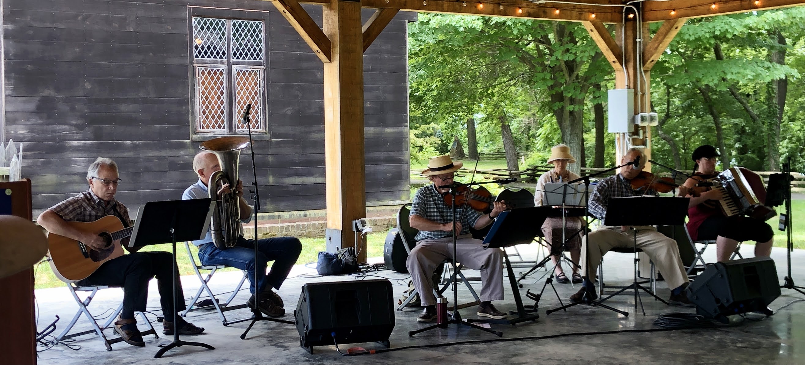
The next day, Friday, June 25, we enjoyed a full day of activities on shore. We kayaked in to the docks of St. Mary's College of Maryland, tied up, and made our way through the end of the lovely campus, pass historic Trinity Church, to Historic St. Mary's City. We followed the sound of music, which was emanating from a pavilion at the edge of historic area. A group of talented musicians was performing a variety of folk music, most of it used to accompany traditional contra dancing, which would have been popular among the original English settlers.
 |
| Local musicians performing folk music |
We stopped at the gift shop to get tickets for walking around the historic area and picked up a map and a schedule of activities. Making our way to the next one scheduled (at 11 a.m.), we stopped to read some of the numerous signs along the paths that explain the history of the area. (I really have a difficult time passing signage at museums and historic sites and natural areas.) The first activity enlightened us on the native Americas who had lived in this area prior to the arrival of Europeans. Archeological evidence indicates that the area has been inhabited for 12,000 years. When the English colonists, led by Leonard Calvert, the brother of the second Lord Baltimore, Cecil Calvert (who had received a royal charter for the area south of the Massachusetts Bay Colony and north of Virginia), arrived in the area in March 1634, they encountered the Yeocomicos and bartered with them for land on the east side of the St. Mary's River near what is now named Horseshoe Bend. The price was some manufactured goods such as cloth and the promise of protection against maurading tribes from the north.
The Yeocomico lived on both sides of the river in a dispersed woodland hamlet, taking advantage of free-flowing fresh water springs, well-drained soil for agriculture and an abundance of food gathered or hunted in the water and on land. They used dugout canoes for transportation on water and participated in extensive trade routes. Copper from the Upper Midwest as well as stones from the American Southwest have been found in excavated sites of the Piscataway nation to which the Yeocomico belonged. They grew beans, corn, squash and melons and cultivated fruit trees, including the peach tree, a species which had been imported by the Spanish to Florida in the 16th century--another indication of the trade among native tribes. They lived in houses called witchotts, constructed of cedar bent when it was green to form a long, arched structure, held together by rawhide strips and covered with indigenous reeds. They wove baskets for various uses, made pottery including tobacco pipe bowls, used shells for wampum, made drums from natural sources such as wood and leather, used atlatls and bows and arrows for hunting, and created clothing from hides and furs.
 |
| Drum and baskets on display in a reconstructed witchott |
 |
| Partially reconstructed witchott showing construction methods |
 |
| Clam shell and wampum beads |
 |
| Furs on display in a reconstructed witchott |
 |
| Sherri wearing a wrap of various furs |
For the first few months of settlement by the white people, while the colonists were constructing their homes, they lived with the native people, who taught them about the area, and, vital for the colonists' survival, how to grow corn and other crops. The industrious colonists, using the labor of indentured servants, who made up more than half of the contingent of about 140 immigrants, built a fort with enclosed dwellings and cultivated the land. Over the sixty years of its existence, St. Mary's City spread out over a considerable span of waterfront and pasture (over 1000 acres), and the structures ranged from recycled witchotts to rude wooden shacks to timber residences and a few brick buildings, including a Jesuit chapel.
The Calverts (the Lords Baltimore), who privately owned the colony, were Roman Catholics at a time when this religion was officially outlawed in England. When the first Lord Baltimore, George Calvert, converted to Catholicism in 1625, he became ineligible to vote or hold public office. After an unsuccessful attemt to establish a colony in Newfoundland, he petitioned King Charles I for land north of Virginia. He died before the charter was granted, but his son, Cecil, the second Lord Baltimore, received the charter. Ony 27 years old, he began the Maryland venture in 1632, putting together the ships, people and supplies to start a colony that he hoped would prove a profitable investment while providing a place for Catholics to worship freely. Interestingly, not all who made the four month voyage were Catholic. Many who signed on were more interested in the prospect of land ownership than religious freedom and agreed to four to seven years of indentured servitude in exchange for land upon completion of the terms of labor.
Approximately 140 people embarked from the Isle of Wight in November of 1633 with Cecil Calvert's younger brother Leonard in charge. (Cecil himself could not go because he needed to remain in England to defend the charter.) Two ships, the Ark and the Dove, set off; they became separated during a storm early on. The Dove was presumed to be lost at sea but rejoined the Ark in the southern Caribbean. Entering the Chesapeake Bay, they sailed up the Potomac River and established themselves temporarily on St. Clement's Island while they explored for a site for a permanent settlement.
Although the settlement was quite successful and became the first capital of the colony of Maryland, the city lasted little more than 60 years. At first, there was growth and progress; between 1634 and 1645, tobacco plantations were developed all around and the population of settlers increased to nearly 600. However, in the 1640s, there was political upheaval in England; Charles I was executed and a Protectorate was established under Oliver Cromwell. This period of civil war extended to the colonies, with the English privateer Richard Ingle capturing St. Mary's City in 1645. Leonard Calvert recovered the colony a year later, but the Calverts lost control again to Protestant enemies between 1654 and 1657. Eventually, the capital of Maryland was moved to Annapolis in 1695 for political, economic and religious reasons, and St. Mary's City, the main function of which was government, faded into obscurity and finally disappeared as all the area was converted for agricultural uses. By 1750, only a few traces of the city remained above the ground.
For nearly 200 years, there was only intermittent interest in the first settlement in Maryland. One archaeological investigation was made in the 1930s and the 1676 brick Statehouse was reconstructed on the 300th anniversary of St. Mary's City. Finally, in the 1960s, with plans for residential development formulated, intense concern for the preservation of the site emerged. Land was acquired by the State of Maryland and surveys and digs began. Over decades of investigation, experts, using historical documents and archeological evidence, were able to determine the layout of the city and the location of specific buildings. Today, some of the buildings have been reconstructed and others have ghost frames showing their placement.
 |
Reconstruction of an ordinary (or lodging establishment)
|
 |
| Set type for a printing press; St. Mary's had the first one south of New England |
 |
| Inside an ordinary, or lodging house/tavern |
 |
| Inside an ordinary |
 |
| Dining area in an ordinary |
 |
| Outside of a typical clapboard structure |
 |
| Jesuit Chapel |
While the layout of the city and many exact building sites have been known for at least a couple decades, the location of the original fort, which has intrigued archeologists for about 90 years, was a mystery. A letter from Leonard to his brother Cecil indicated the dimensions and the distance from the waterfront, but little else was known. Then, in 2019, archaeological geophysicist Tim Horsly, using ground-penetrating radar, detected the outlines of the palisaded fort; particularly, scans revealed the imprint of post holes that formed a large rectangle with a semicircular bastion at one corner. Due to the pandemic, the results were not released to the public until March of this year, and actual excavation began just recently. Peter and I felt extremely fortunate to join a limited tour of the dig site, where the field students explained their work and showed us some of the artifacts they had discovered in the past few days. We were also reminded of visiting Jamestown while we were sailing on Epicurus with the kids in 2006 and were thrilled to find a new dig there of the recently discovered site of the original fort of that Virginia settlement.
 |
| Original iron nail from the fort |
 |
| Evidence of post holes for the palisades |
 |
| Archaeology student showing a pottery fragment |
 |
| Slow, meticulous work with trowels and chisels |
After the tour of the fort excavation site, we continued on our own for a couple hours following the paths and learning more about this fascinating place, finally completing our tour around 5 p.m. Peter kayaked back to the boat to get chairs and turn on the anchor light. When he returned, we made our way to the large white tent forming a half-dome over a stage on campus to enjoy a free concert sponsored by the college and performed by the Chesapeake Orchestra and a talented mezzo-soprano. There was a large crowd for this concert, the first since early 2020 of the River Concert Series, and numerous food trucks. We purchased healthy Middle Eastern food, which we consumed before the performance started. The first half consisted Hector Berlioz's Les Nuits d'ete, a song cycle featuring six poems by Théophile Gautier. After intermission, the program included popular 20th century pieces including Moon River, Night and Day, More and Someone to Watch Over Me. The singer had a powerful, goosebump inducing voice. The concert was a wonderful conclusion to a great day on land. We returned to Mantra at sunset.
 |
| Audience gathered on a pleasant summer evening for a River Concert |
 |
| Musicians warming up |
 |
| Mantra anchored in Horseshoe Bend |
The next day, Saturday, June 26, we pulled up anchor at 9:30 and set off for Solomons, Maryland. We had to motor in the morning due to insufficient wind, but in the afternoon, with wind up to 18 knots, we cruised along under sail on a comfortable broad reach, doing 7 to 9 knots, for three hours on the bay, only turning the engine on again to maneuver up the Patuxent River and Back Creek to the Spring Cove Marina at Solomons. It had been hot day, and we did not lose any time after tying up making it to the cool relief of the swimming pool. On the pool deck, happy hour was in full swing, so we bought drinks and socialized. After refreshing showers, we walked into town to a restaurant we had visited on a previous trip, the CD Cafe. It's a small place with great food, and we were lucky to get a table right away on a Saturday night. Walking back to the marina, we were enchanted by fireflies dancing above the lawns and in the shrubbery.
At 10 a.m. on Sunday, June 27, we were at the Calvert Marine Museum when it opened. We were expecting little and were amazed with the extent of the museum's collections and with the professional and engaging presentations. First, we learned about rays and skates and saw some swimming in a pool; it was fascinating to learn about their differences in physical traits and reproduction. Next we entered the hall of paleontology, where there was quite impressive display of fossils and excellent educational graphics worthy of a world-class museum. The town of Solomons is at the southern end of the Calvert cliffs which border the Chesapeake Bay in that area. For 35 miles, there is an unbroken exposure of fossil laden strata An amazing array of fossils has been found over the past two centuries, most from the Miocene, from 3 to 10 million years ago, when the area was a seabed that experienced successive periods of high and low water. During that time, the area was tropical, and land species included crocodiles, tapirs and camels.
 |
| Peter looking at the fossil display |
 |
| Peter in front of the skeleton of a megaladon |
Other areas of the museum focused on the Chesapeake as an estuary, maritime history, wartime history, oyster harvesting and packing, commercial fisheries and boat building in Southern Maryland. Outside, there is a large display of traditional wooden boats, from log canoes to mid-20th century fishing vessels. The Drum Point Lighthouse is also on the grounds of the museum. This 1883 screw pile light was decommissioned in the 1960s and moved to the site in 1975.
 |
| Boat with attachment for sucking up clams |
 |
| Boats for oystering and fishing |
 |
| Two and three log canoes |
 |
| Fishing boat restored and used for waterfront tours |
 |
| Drum Point Lighthouse |
We wanted to continue our movement up the bay, so we only stayed two and a half hours, but we could have spent much more time at this little gem of a museum. We cast off the dock at 1 p.m. and had the engine off in less than a half hour, average 7 knots under sail all the way to the mouth of the Little Choptank River on the eastern shore of the Chesapeake Bay.
This morning (Monday, June 28), with very light winds, we managed to average 3 knots on a deep broad reach to the mouth of the Tred Avon River, which feeds the Choptank. The anchorage in Town Creek next to the town of Oxford we found to be too shallow and to narrow for anchoring, so we crossed the Tred Avon to the opposite shore and found a lovely place to anchor on Plaindealing Creek. We dinghied into Oxford to check it out for leaving the boat while we are at the beach in Ocean City, Maryland, July 17-24, and afterwards, when we return to California on another cross-country road trip to get ready to descend the Colorado River through the Grand Canyon in September. The heat and humidity were killer, and we were happy to eat indoors at a waterfront restaurant called Capsize, which has excellent fare. Then, I walked to the post office and the little store while Peter went to Oxford Boatyard to discuss projects that (still) need to be done on Mantra. I passed many lovely homes on my walk as well as the three hundred and eleven year old Robert Morris Inn and Tavern.
We are back on board, and there is a nice breeze, but it is still sticky and there are extremely annoying flies which I take great pleasure in swatting to death whenever possible. Now it's time for a light dinner, a refreshing shower and air conditioning!


Thoroughly enjoyed this!
ReplyDelete